Apa terjadi sekarang dengan kebijakan moratorium kehutanan di Indonesia? Dari tahun 2011 saat moratorium pertama kali disahkan selalu dipandang sangat lemah tapi setidaknya ada sedikit lindungan untuk hutan Indonesia yang masih utuh. Namun, sekarang perusahaan kelapa sawit sepertinya sudah bebas mempengaruhi dan merubah peta moratorium seenaknya.
Pada tahun 2011 pemerintah Indonesia sepakat untuk menunda pemberian izin baru di atas lahan hutan primer atau lahan gambut difasilitasi dana dari Norwegia sebanyak $1 miliar. Moratorium ini berlaku selama dua tahun tapi diperbarui kembali oleh Presiden SBY pada tahun 2013. Setiap enam bulan Departemen Kehutanan menerbitkan revisi baru dengan beberapa perubahan areal moratorium.
Revisi kelima diterbitkan pada akhir tahun 2013. Banyak kawasan hutan dikeluarkan dari peta moratorium akibat permintaan langsung dari perusahaan perkebunan. Sepertinya kalau sebuah perusahaan ingin membuka kebun di lahan moratorium, tinggal menyurati dephut saja dengan mengatakan lahan sasaran mereka bukan hutan primer atau lahan gambut dan lahan itu akan dihapus dalam revisi peta moratorium berikutnya.
Banyak perusahaan kelapa sawit di Tanah Papua ikut meninjau kembali peta moratorium, setelah beberapa perusahan perkebunan tersebut ditolak izin pelepasan kawasan hutan pada tahun 2013, misalnya, PT. Tunas Sawaerma, PT. Visa Hijau Nusantara, PT. Wahana Agri Karya dan PT. Duta Visi Global ((PT Tunas Sawa Erma adalah anak perusahaan konglomerat Korsel-Indonesia Korindo yang cari perluasan perkebunan yang sudah beroperasi selama beberapa tahun. Walaupun Korindo barangkali juga terlibat mengurus izin untuk ketiga perusahaan lainnya (PT Visi Hijau Nusantara, PT Wahana Agri Karya dan PT Duta Visi Global), belum tentu mereka juga anak perusahaan Korindo. Bisa jadi bahwa Korindo, yang punya hubungan baik dengan pihak pemerintahan dan keamanan di daerah itu mungkin mempermudah masuknya perusahaan lain, seperti sudah dilakukan dengan Daewoo International di daerah Muting, Merauke.)) , yang sedang dalam proses perizinan untuk menguasai sebuah koridor lahan kurang-lebih ikut jalan Trans-Papua dari Asiki ke Tanah Merah sampai Mindiptana di Kabupaten Boven Digoel.
Keempat perusahaan tersebut sudah dapat izin lokasi dari pemerintah kabupaten namun ditolak oleh kehutanan di pusat, barangkali karena sebagian dari arealnya masuk peta moratorium. Mereka menulis kepada departemen kehutanan pada November 2013, bahwa mereka mengklaim seluruh kawasan hutan itu adalah hutan sekunder. Permintaannya lalu diterima oleh kehutanan dan beberapa minggu kemudian kawasan hutan itu dikeluarkan dari areal hutan moratorium.
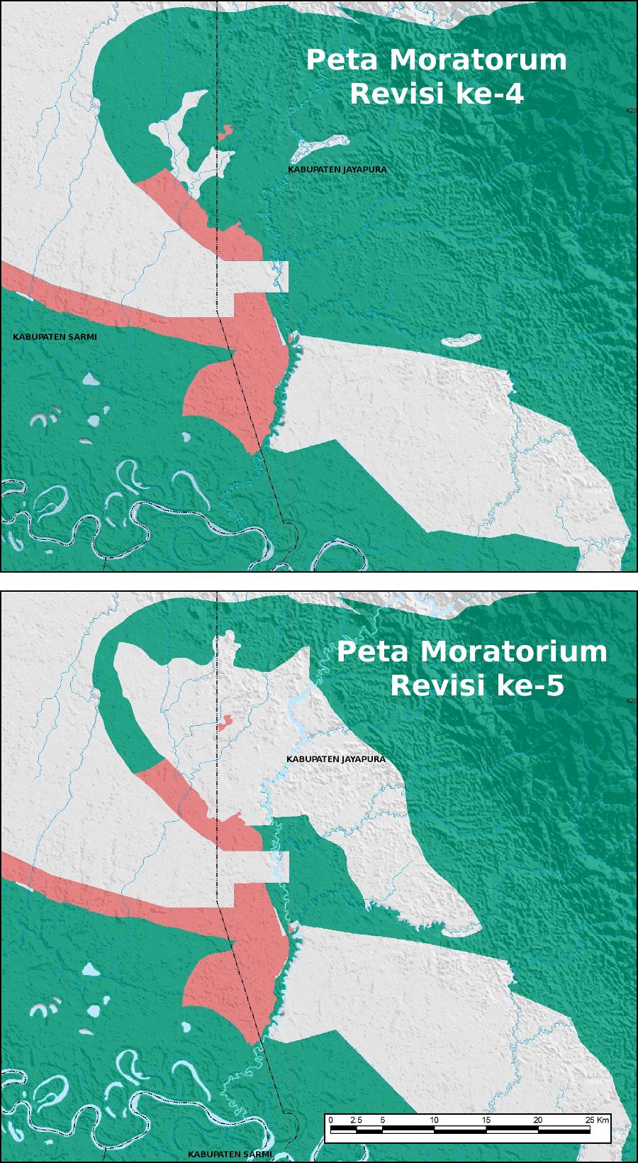
Di bawah adalah kedua versi petanya – warna hijau tunjukkan hutan primer dan warna pink adalah lahan gambut. Seharusnya lahan dalam warna abu-ab adalah hutan sekunder dengan tanah mineral atau sudah dibebani izin yang sudah berlaku saat moratorium diresmikan pada tahun 2011.

Data tentang penutupan lahan juga tersedia di web kehutanan. Dapat dilihat bahwa sebagian lahan di konsesi-konsesi itu adalah hutan primer dan sebagian lain hutan sekunder. Setelah lepas dari moratorium, pada tanggal 6 February 2014, keempat perusahaan ini dapat persetujuan prinsip untuk melepaskan kawasan hutan oleh menteri kehutanan.
Kasus lain ada di bagian selatan Kabupaten Jayapura, dekat Sungai Mamboramo. Dua anak perusahaan PT Musim Mas sudah dapat izin untuk buka perkebunan di sana. Walaupun lahan memang hutan primer, tetapi arealnya tidak masuk peta moratorium pertama tahun 2011. Sekarang anak perusahaan lainnya, PT Inti Benua Perkasatama ((Awas MIFEE belum dapat peta yang tunjukkan batas konsesi PT Intibenua Perkasatama untuk melihat kalau peta sama dengan areal dikeluarkan dari peta moratorium. Sebenarnya areal dikeluarkan dari peta moratorium lebih luas dari konsesi PT Intibenua Perkasatama. Kemungkinan besar lubang abu-abu ini juga mencakup areal PT Daya Indah Nusantara, juga anak perusahaan PT Musim Mas.)) mengajukan 25.773 hektar lagi di lokasi sekitar. PT Inti Benua Perkasatama mengeluh kepada departemen kehutanan pada Mei 2013. Menurut mereka lahan tersebut adalah hutan sekunder dengan tanah mineral. Klaim ini agak sulit untuk dipercayai, sebab di peta tutupan lahan dari departmen kehutanan yang sama, diketahui areal itu jelas dikelilingi hutan primer sampai puluhan kilometer di setiap arah. Fakta kawasan hutan primer tersebut tidak ada pengaruhnya, peta moratorium revisi kelima yang baru telah berubah menjadi lubang abu-abu.
Di Pantai selatan Papua, di bagian barat kabupaten Mimika, PT Tunas Agung Sejahtera (TAS) ((Setahu awasMIFEE, PT Tunas Agung Sejahtera dimiliki PT Pusaka Agro Sejahtera, sebuah perusahaan yang sangat menghindari punya citra kepada umum. Selain di Timika, PT. Pusaka Agro Sejahtera sudah mendapatkan izin untuk perkebunan kelapa sawit di Sorong Selatan, Maybrat dan Jayapura.)) sudah dapat izin lokasi untuk perkebunan kelapa sawit seluas 40.000 hektar. Di bawah dapat dilihat peta konsesi TAS dengan indikasi batas konsesi. Perusahaan ini juga menyurati departemen kehutanan pada November 2013, juga mengklaim bahwa seluruh lahan adalah hutan sekunder. Permintaan ini diterima tapi sepertinya terlambat untuk dimasukkan ke revisi kelima peta moratorium. Departemen kehutanan mencatat bahwa ini akan menjadi bahan revisi keenam.
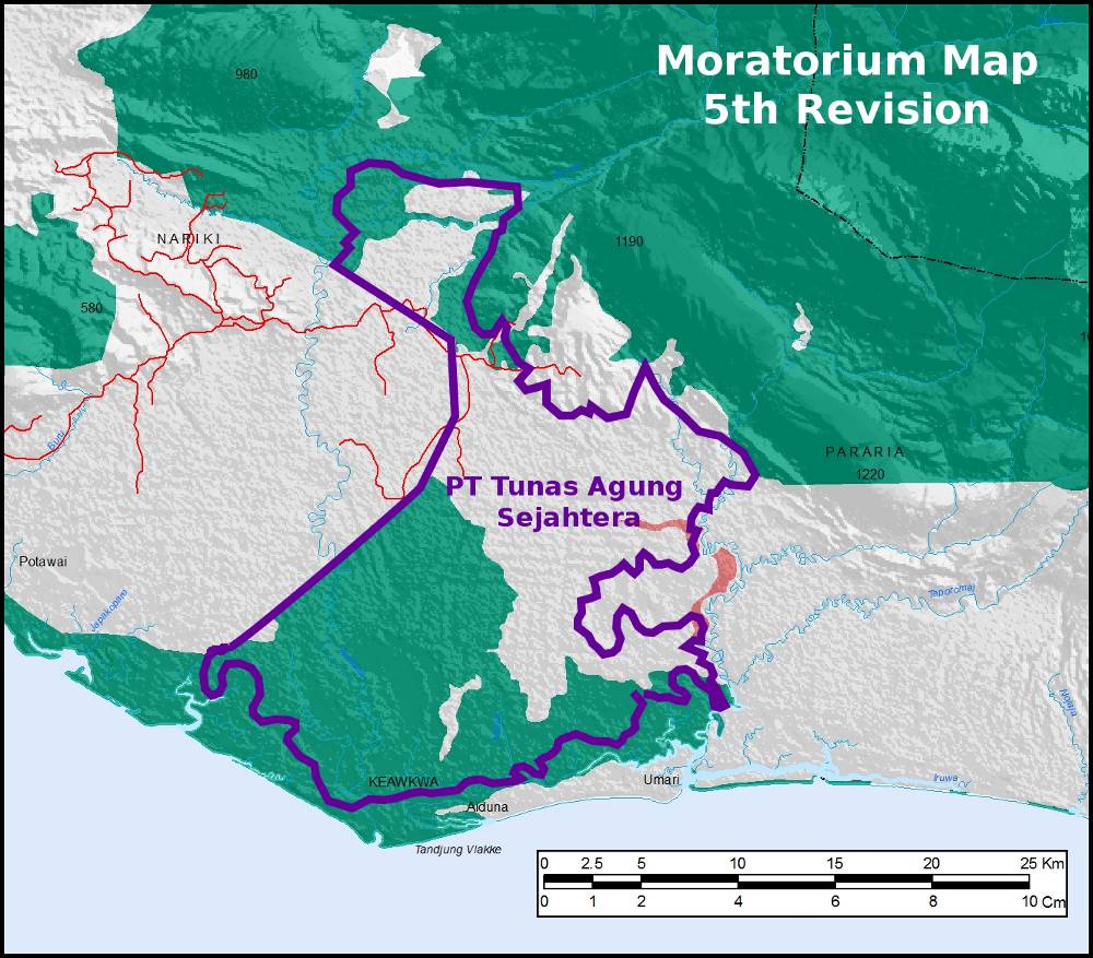
Pada tanggal 19 Maret 2014, menteri kehutanan mengeluarkan izin persetujuan prinsip melepaskan kawasan hutan kepada PT. Tunas Agung Sejahtera, walaupun secara nyata dalam versi peta moratorium yang sekarang berlaku (revisi kelima) sebagian besar dari arealnya seharusnya masih dilindungi melalui kebijakan moratorium.
Ada banyak kasus lagi di Tanah Papua, seperti: perusahaan kelapa sawit PT Inti Kebun Sejahtera dan PT Inti Kebun Sawit (Kayu Lapis Group) di Sorong, PT Daya Indah Nusantara (Musim Mas Group) di Sarmi, PT HCW Papua Plantation di Bintuni dan PT Mega Mustika Plantation di Sorong (group-nya belum diketahui) juga mengajukan revisi dan semuanya diterima. Perusahaan kayu PT Semarak Dharma Timber (Patria Group) di Keerom dan perusahaan tambang PT Gag Nickel di Raja Ampat (sekarang 100% sahamnya sudah milik ANTAM) juga berhasil.
Tidak satupun perusahaan di Tanah Papua yang menyurati departemen kehutanan selama tahun 2013 ditolak (kecuali PT Inti Kebun Sejahtera pada bulan Maret, namun pada bulan Oktober baru berhasil diterima). Pola di Kalimantan dan Sumatera sama juga. Ringkasan dari seluruh masukan diterima Dephut bisa diunduh dari web kehutanan. Peta-peta juga bisa dilihat di sini.
Pasti setiap kasus berbeda dan dokumentasi lengkap tidak tersedia online. Namun yang paling nyata adalah departemen kehutanan sangat bersedia untuk merubah peta moratorium setiap kali ada keperluan dari sebuah perusahaan. Juga sangat cepat untuk bergerak, padahal kalau kita hitung bahwa untuk menentukan secara definitif kondisi hutan dan komposisi tanah di lokasi-lokasi yang cukup besar dan terpencil pasti membutuhkan survei terperinci.
Revisi berikutnya akan diterbitkan pada bulan Juni 2014. Mari kita lihat kalau ada hutan primer dihapus lagi. Moratorium hanya ada sekarang, tetapi dapat berubah sampai ada perusahaan yang minta dilepaskan dari kendalanya. Ini bukan pertama kali departemen kehutanan dituduh keluarkan lahan dari peta moratorium atas permintaan perusahaan (di Papua misalnya sudah pernah jadi di areal MIFEE di Merauke dan PT Sumber Indah Perkasa di Kabupaten Jayapura). Namun sekarang semakin sering dan semakin sangat jelas.