Dengan sebuah alat baru di web Sawit Watch kita bisa lihat dengan muda di mana ada titik api dalam konsesi perkebunan kelapa sawit. Misalnya minggu ini (1 – 5 Agustus) kelihatan ada empat titik api di dalam lokasi PT Dongin Prabhawa (Korindo Group) di Merauke
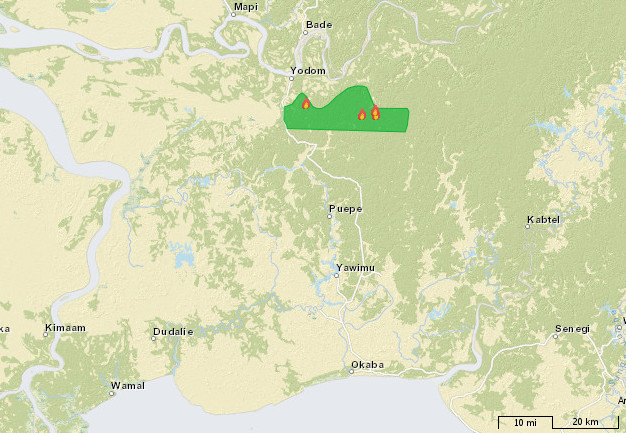 Lihat sendiri di web http://gis.sawitwatch.or.id/ Sayangnya data tentang keberadaan perkebunan kelapa sawit adalah data lama dan beberapa perkebunan tidak pernah jadi. Ada juga yang baru yang tidak muncul di situ. Namun alat ini memang sangat menarik.
Mengunakan api untuk membersihkan hutan melanggar hukum dan mencemari udara tetapi terus-menurus terjadi. Data di web Sawit Watch ini (lihat juga http://geodata-cso.org/) juga tunjukkan situasi jauh lebih parah di Sumatera dan Kalimantan, walaupun sudah terbukti bahwa asap ini sangat menganggu kesehatan umum di Indonesia, Malaysia dan Singapura. Namun kebakaran hutan tetap terjadi, sering untuk membuka lahan yang akan ditanami kelapa sawit.