What’s been going on with Indonesia’s forestry moratorium? Since it was introduced in 2011 it has always been recognised as quite weak, but some protection for Indonesia’s forest at least. However now it seems that oil palm companies are free to just redraw the map at will.
In 2011 Indonesia agreed to place a moratorium on all new permits on primary forest and peatland, in exchange for $1 billion from the Norwegian Government. That moratorium was valid for two years, but then the President extended it for two years more in 2013. Every six months the map of areas covered by the moratorium is revised if there are any changes necessary.
The fifth update to this map was published at the end of 2013. A lot of the changes made were after direct appeals from plantation companies. It is as if all a company has to do to change the map is send a letter to the forestry department, claiming its concession is not primary forest, and the forestry department will obligingly remove it from the next edition.
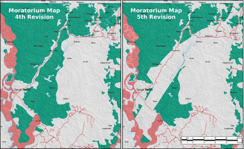
Plantation companies in Papua have been some of the most active in appealing the moratorium map, after many were refused permission to use state forests during 2013. For example, PT Tunas Sawaerma, PT Visi Hijau Nusantara, PT Wahana Agri Karya and Duta Visi Global ((PT Tunas Sawa Erma is a subsidiary of the Korean-Indonesia conglomerate Korindo, and is applying for an extension of its existing plantation. The other three companies (PT Visi Hijau Nusantara, PT Wahana Agri Karya and PT Duta Visi Global) appear to have made their application jointly with Korindo. However, they may not be subsidiaries. Korindo, an established business in the area with several oil palm plantations, large timber concessions and a plywood factory, may be using its local contacts to facilitate another company’s operation. This already happened with the case of Korean Multinational Daewoo International, which Korindo helped to establish plantations in Merauke.)) are four companies which are trying to obtain permits on a strip of land roughly following the route of the Trans-Papua road going north through Boven Digoel from Asiki to Tanah Merah and on towards Mindiptana.
Those four companies obtained location permits from the local government, but then the forestry department refused their request to use state forest land, presumably because some of that land was covered by the moratorium. However, the companies wrote to the forestry department in November 2013. They claimed the land was all secondary forest. The forestry department accepted their appeal and a few weeks later the land was duly removed from the area under moratorium.
Here are the two versions of the map – green areas are primary forest and pink areas are peatland. In theory the grey areas are either secondary forest or were already covered by an existing permit when the moratorium came into force in 2011.

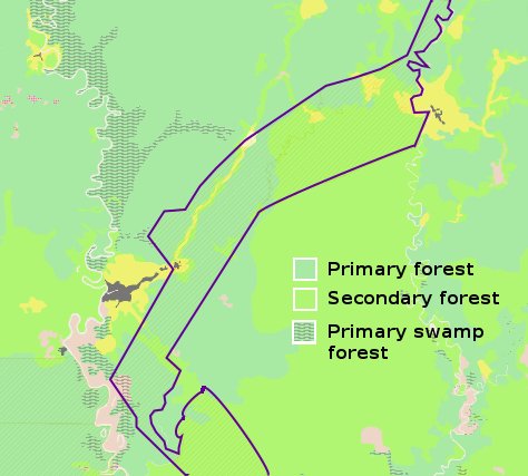
The forestry department’s website also shows information on land cover. It can be seen that according to that data the concession areas do actually consist of a mixture of primary and secondary forest. Nevertheless, on 6th February 2014 the four companies were all awarded an in-principle permit to release the land from the state forest estate.

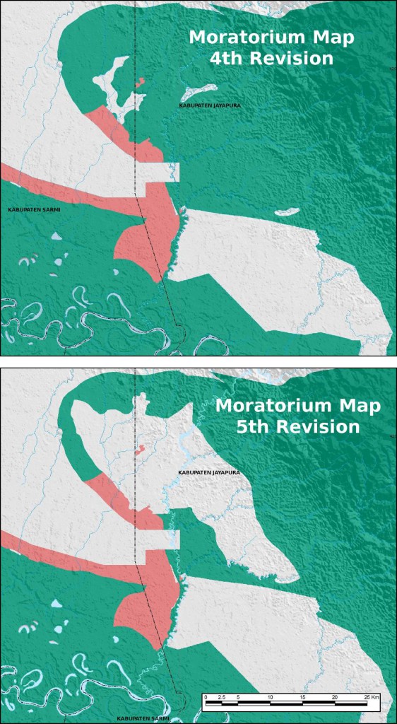
Another case is in the south of Jayapura Regency, near to the Mamboramo River. The Musim Mas group already has all the permits it needs to start two plantations there – even though the land is primary forest it was not included in the original 2011 moratorium area. A third subsidiary, PT Inti Benua Perkasatama ((Awas MIFEE has not been able to obtain an exact map of PT Inti Benua Perkasatama’s location permit to verify whether the boundaries of the area snipped are the same. In fact the area cut from the map is almost certainly also takes in the concession of PT Daya Indah Nusantara, another Musim Mas subsidiary, judging from its size and the small area of peatland which is left as part of the moratorium., is applying for another 25773 hectares in the same area.)) This company complained to the forestry ministry in May 2013, claiming the land was secondary forest, with mineral soils. This seems somewhat unlikely, as the area is very remote, and all the land for many kilometres in every direction is classified as primary forest by the forestry department. Nevertheless, a neat hole was snipped out of the map.

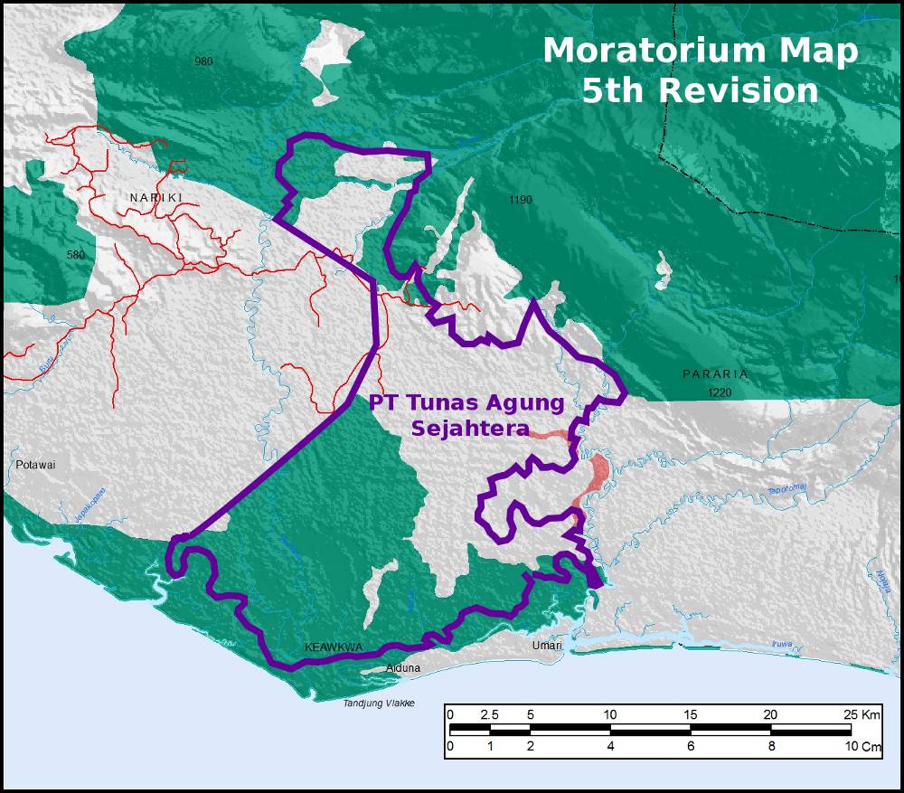
On Papua’s south coast, in the western part of Mimika regency, PT Tunas Agung Sejahtera ((PT Tunas Agung Sejahtera is to the best of our knowledge owned by PT Pusaka Agro Sejahtera, a company which avoids having any kind of public profile, but has acquired permits for plantations in Sorong Selatan, Maybrat and Jayapura as well as Timika.)) has a location permit for 40,000 hectare plantation. The boundary is shown on the map below. This company also wrote to the forestry department in November 2013, again claiming that the land was secondary forest. It appears that their appeal was accepted but missed the deadline for inclusion in the fifth revision of the moratorium map. The forestry department noted that it would make the changes in the sixth revision.

And then it gave the company the permit anyway, despite the fact that under the current moratorium map, the land is still supposedly protected. PT Tunas Agung Sejahtera got its in-principle permit on 19th March 2014.
There are many more cases: in Papua alone, the plantation companies PT Inti Kebun Sejahtera and PT Inti Kebun Sawit (Kayu Lapis Group) in Sorong, PT Daya Indah Nusantara (Musim Mas Group) in Sarmi, PT HCW Papua Plantation in Bintuni and PT Mega Mustika Plantation in Sorong (corporate group unknown) also made appeals and were granted revisions. Timber company PT Semarak Dharma Timber (Patria Group) in Keerom and mining company PT Gag Nickel in Raja Ampat (now wholly owned by state-owned miner ANTAM) were also successful.
None of the Papuan companies which applied were turned down, although a first appeal by Inti Kebun Sejahtera had been refused earlier in the year, and a similar pattern emerged in Kalimantan and Sumatra. A summary list of all the submissions received was published by the forestry department which you can check out for yourself here. The maps are here.
The full details of each individual case have not been made public, and the circumstances are undoubtedly different in each one. Nevertheless, the forestry department seems to have been very amenable to making changes, and remarkably swift too, considering that deciding whether these large and remote areas do in fact contain degraded forest and mineral soils would require detailed surveys.
The next revision is due in June so let’s see what happens. But if things go on like they have been doing recently, it is only a moratorium until a company asks to be exempted from it. This is not the first time that the forestry department has been accused of excising areas from the map to order (for example in the MIFEE area in Merauke or PT Sumber Indah Perkasa’s concession in Jayapura). But now it seems to be on a much larger scale and much more blatant.
